
Timeline & Connection of Bangalore Vijayawada Expressway with the Failed project Ananthapur Amaravati Expressway:
It was year 2014, when Andhra Pradesh state of India got separated into two states viz. Andhra Pradesh & Telangana. After separation, Nara Chandrababu Naidu from Telugu Desam Party (TDP) became the first chief minister of New Andhra Pradesh who in past was also the 2 times chief minister of old Andhra Pradesh.
The southern part of today’s Andhra Pradesh is called as the Rayalaseema region which is among the backward areas of the state which often suffers from drought. In the year 2016, N Chandrababu Naidu proposed an Expressway from Anantapur to Amravati which would connect the districts of the Rayalaseema region directly with Amaravati, the Capital of Andhra Pradesh thereby would provide a push to socio and economical growth of the Rayalaseema region.
In year 2017, the work initiated for the preparation of detailed project report for Amaravati Anantapur Expressway & in year 2018, Land Acquisition for the same started.
In year 2019, State assembly elections took place in Andhra Pradesh which resulted in the fall of Telugu Desam Party and eventually dropping out N Chandrababu Naidu as CM. This time, people of AP elected for YSRCP & the party selected YS Jaganmohan Reddy as the new chief minister of Andhra Pradesh.
The formation of New Government adversely affected the work of Ananthapur Amaravati Expressway resulting in the slower pace of work.
In year 2020, YS Jaganmohan Reddy government approved the bill which had the provision of 3 capitals in the state under which YSRCP wanted to form 3 different capitals viz. Visakhapattanam, Kurnool & Amaravati. The party wanted to make Vizag as the state executive capital, Amaravati as state legislative capital and Kurnool as judiciary capital. However, till today, YSRCP could not form the 3 capitals. But after the actions taken by the government regarding the same had adversely affected the project of Anantapur to Amaravati Expressway & reports started to come out regarding the uncertain fate of the expressway project.
The reports got real in year 2020 when YSRCP government changed and shifted the alignment of earlier proposed Anantapur Amaravati Expressway project & proposed the Bangalore Vijayawada Expressway which also got the approval from centre.
According to reports, YS Jaganmohan Reddy and the party was not happy with the alignment proposed under Amravati Ananthapur Expressway project. It is believed that the earlier proposed alignment was acting as a hindrance to the agenda for 3 capitals in Andhra. Along with this some reports also says that providing benefits to the current constituency, Pulivendula & previous constituency, Kadapa of the chief minister YS Jaganmohan Reddy were also among the important reasons behind the shift of the alignment or route of previously proposed Amaravati Anantapur expressway.
Additionally, some reports also says that by adopting the route alignment for the proposed Bangalore Vijayawada expressway instead of adopting the route for the previously proposed project, approximately INR 3,000 crores of government funding will be saved hence the YSRCP govt adopted the new alignment.
So these were some of the reasons behind the drop of previously proposed project & adoption of the proposal of Bangalore Vijayawada Expressway.
Also Read- 74 Kms long Bangalore Peripheral Ring Road Finally Happening ! See Project Details.
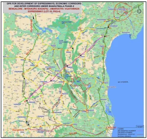
Route Alignment of Bangalore Vijayawada Expressway
The expressway will be a combination of greenfield and brownfield alignment. The project will be developed under phase 2 of India’s ambitious programme Bharatmala Pariyojana.
B’lor Vijayawada expressway will be a partially controlled expressway. The stretch of the same will be constructed in Karnataka and Andhra Pradesh.
Bangalore Vijayawada Expressway will pass through 1 district in Karnataka & 7 districts in Andhra Pradesh State. The freeway will start from Bangalore in Karnataka, and after entering Andhra Pradesh it will cross Anantapur, YSR Kadapa, SPS Nellore, Prakasham, Bapatla, Palnadu and will Guntur near Vijayawada.
If we look route alignment in more detail, the expressway will start from Satellite Town Ring Road (under construction ) in Devanahalli near Bangalore, continuing ahead on Bangalore Hyderabad NH 44 will then pass through Chikkaballapur, Peresandra, Begepalli. Expressway will then enter Andhra Pradesh and will reach Kodikonda and here, the Greenfield Section of the B’lor Vijayawada Expressway will start.
Moving ahead, the expressway will cross Gorantla, Gagampalli, Nallamada, Malakavemala, Pulivendula, Animela, Yerraguntala, Mydukur, Mallepalli, Cumbum forest range, Vangapadu, Kanigiri, Yeluru, East Gangavaram & will reach Addanki. Here in Addanki, the freeway will merge with existing NH-16. Moving ahead on existing NH-16, the expressway will cross Valaparla, Martur, Chikkaluripet and will reach Guntur. And from Guntur, the expressway will get its connectivity with Vijayawada.
Also Read- 74 Kms long Bangalore Peripheral Ring Road Finally Happening ! See Project Details.
Brownfield & Greenfield Sections of Bangalore Vijayawada Expressway
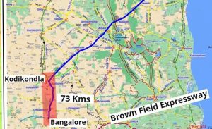
Here the 73 kms Highway section from Bangalore to Kodikonda (NH -44) will be a Brownfield Section of the project where the existing 4 lane National Highway will be upgraded to expressway standards.
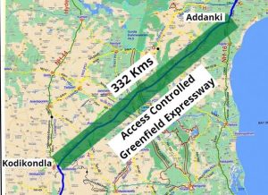
332 Km section from Kodikonda to Addanki will be constructed as 6 lane completely access controlled Expressway.
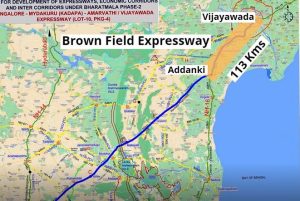
Moving on, 113 Km section from Addanki to Vijayawada will be constructed as a brownfield expressway where existing highways will be upgraded to Expressway standards
Combining each stretch (Brownfields + Greenfield), the total length of Bangalore Vijayawada Expressway will be 518 Kms in which 332 Kms will be a Greenfield Expressway with fresh alignment & remaining 186 Kms section will be a Brownfield type Expressway.
Currently, the distance between Bangalore and Vijayawada is somewhere around 660 Kms & it takes almost 12 hours to travel. After successful completion of Bangalore Vijayawada Expressway, the existing distance between the same will be cut down by around 100 Kms. Along with shorter distance, High quality access controlled expressway will facilitate the mobility with help of which it will take just around 6 hours to reach Vijayawada from Bengaluru. In other words, we can say that the travel time will almost cut to half.
74 Kms long Bangalore Peripheral Ring Road Finally Happening ! See Project Details.
Salient Features of Bangalore Vijawada Expressway
The expressway will have a flexible type pavement which means the carriage way will be constructed using Bitumen/Asphalt. In the Brownfield section, the Right of Way of the Expressway will be according to existing National Highways whereas on the Greenfield Section, the Right of Way of B’lor Vijayawada Expressway will be kept as 90 m.
The expressway is being designed in such a way that commuters can move with a speed of 100 kmph. Each lane will be 3.75 m wide. Median will be constructed in depressed manner. Along with this the Service roads will also be constructed on both sides of the expressway in staggered manner.
Around 767 structures will be constructed in the stretch of Bengaluru Vijayawada expressway which includes 1 Railway Over Bridge, 28 Major Bridge, 299 Minor Bridges, 45 Vehicular Underpass, 81 Light Vehicular Underpass, 11 Double Trumpet Type Interchange, 2 Trumpet type Interchange, 300 Culverts.
According to certain reports, approx 1.83 km long viaduct & 2.90 Kms long tunnel will also be constructed in the Pallakonda Hill Area.
Advanced toll collection mechanism will be installed on Bangalore Vijayawada Expressway. In Addition to this, Way Side Amenities, CCTV Cameras, Emergency Calling Booths, Fuel Stations etc will also be installed on regular intervals of the motorway.
Land Acquisition Details of Bangalore Vijayawada Expressway.
Throughout the stretch, the Bangalore Vijayawada expressway will cross more than 253 villages & for the construction of the project Approx 3,500 Hectares of land will be acquired for which the Centre will spend approx INR 5,000 Crores.
Construction cost of Bangalore Vijayawada Expressway Project
Site Clearance & Dismanteling Work – INR 48 Cr
Earth work – INR 3,700 Cr
Base Work – INR 1170 Cr
Paving Works – INR 1050 Cr
Bridge Works- INR 2200 Cr
Culverts – INR 450 Cr
Underpasses – INR 1950 Cr
Railway Over Bridge – INR 60 Cr
Drainage & Protective Works – INR 950 Cr
Interchanges – INR 1170 Cr
Tunnels – INR 1600 Cr
Junctions, Toll Plazas, Amenities etc- INR 34 Cr
Traffic Sign Markers Etc – INR 228 Cr
Miscellaneous Works – INR 90 Cr
In Addition to this, the Land Acquisition cost is estimated as approx 5,000 Cr. Combining all the Civil construction cost & Land Acquisition cost, The overall cost of Bengaluru Vijayawada Expressway will be somewhere around 20,000 Crores.
Knowing these huge figures, one can understand how large scale project is Bangalore Vijayawada Expressway going to be.
Find more details on the project here :
74 Kms long Bangalore Peripheral Ring Road Finally Happening ! See Project Details.